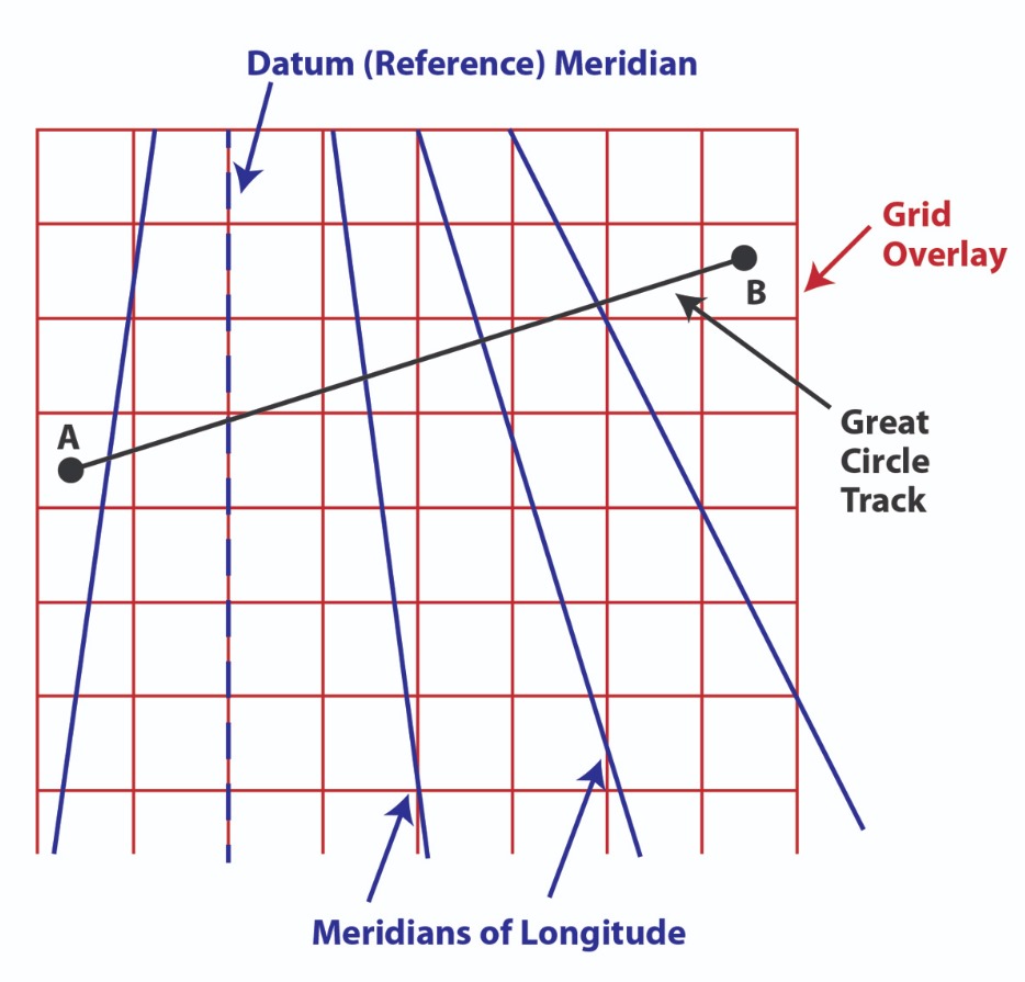
Grid navigation

Grid navigation
Grid navigation is somewhat obsolete because of GPS and Inertial navigation systems, but nevertheless is still part of your ATPL syllabus and you must be able to do it on paper.
Three main challenges drove the development of grid navigation:
The convergence of longitude meridians, which required constant true heading adjustments
Magnetic pole proximity, causing unreliable compass readings
Limited ground-based navigation aids in remote areas
The solution involved overlaying a grid on navigation charts, typically aligned with a reference meridian (most commonly the Prime Meridian at 0 degrees). This system became known as "Greenwich Grid" when using the Prime Meridian as reference.
Concepts
Grid Convergence: The angular difference between True Track and Grid Track, measured from Grid North to True North
Datum Meridian: The longitude where True North equals Grid North
Grivation: The sum of magnetic variation and convergence
Variation: The angle between Magnetic and True North
When converting between different reference systems, pilots follow these principles:
Magnetic/True: "Variation east, magnetic least"
Grid/True: "Convergence east, true track least"
Magnetic/Grid: "Grivation east, magnetic least"
Consider a flight from Iqaluit to Resolute Bay in Northern Canada. The process involves:
Initial Setup
Calculate grid heading for the runway
Align aircraft with runway centerline
Switch from magnetic to directional gyro
Adjust heading reference to grid value
During Flight
Compensate for longitude changes
Use celestial navigation to verify position
Make periodic heading corrections
Approach and Landing
Conduct final heading check
Either maintain grid reference or switch to local true reference
For aircraft entering polar regions mid-flight, crews would:
Determine true heading through celestial observation
Apply appropriate convergence calculations
Switch from magnetic to grid reference
When exiting polar regions, the process reverses:
Verify true heading
Calculate magnetic heading using local variation
Transition from grid to magnetic reference
This system provided reliable navigation in challenging regions before modern electronic navigation systems became standard.
Let's work through a practical example of converting headings at Iqaluit Airport (CYFB):
Given information:
Airport location: 63°45'N 68°33'W
Runway: 34 (Magnetic heading 345°)
Magnetic variation: 29°W
Using Greenwich meridian (0°) as Datum Meridian
Method 1: Using True Heading as Intermediate Step
Convert Magnetic to True heading:
Rule: "Variation west, magnetic best"
345° - 29° = 316° True heading
Convert True to Grid heading:
Convergence = Local longitude = 68°33'E (rounded to 69°E)
Rule: "Convergence east, true track least"
316° + 69° = 025° Grid heading
Method 2: Direct Magnetic to Grid Using Grivation
Calculate Grivation:
Grivation = Variation + Convergence
29°W + 69°E = 40°E (algebraic sum of opposite directions)
Apply Grivation to get Grid heading:
Rule: "Grivation east, magnetic least"
345° + 40° = 025° Grid heading
Both methods arrive at the same grid heading of 025°, which would be used to align the directional gyro before takeoff.

Attila Kis
ATPL Course Supervisor
a.kis@easy-pilot.com

